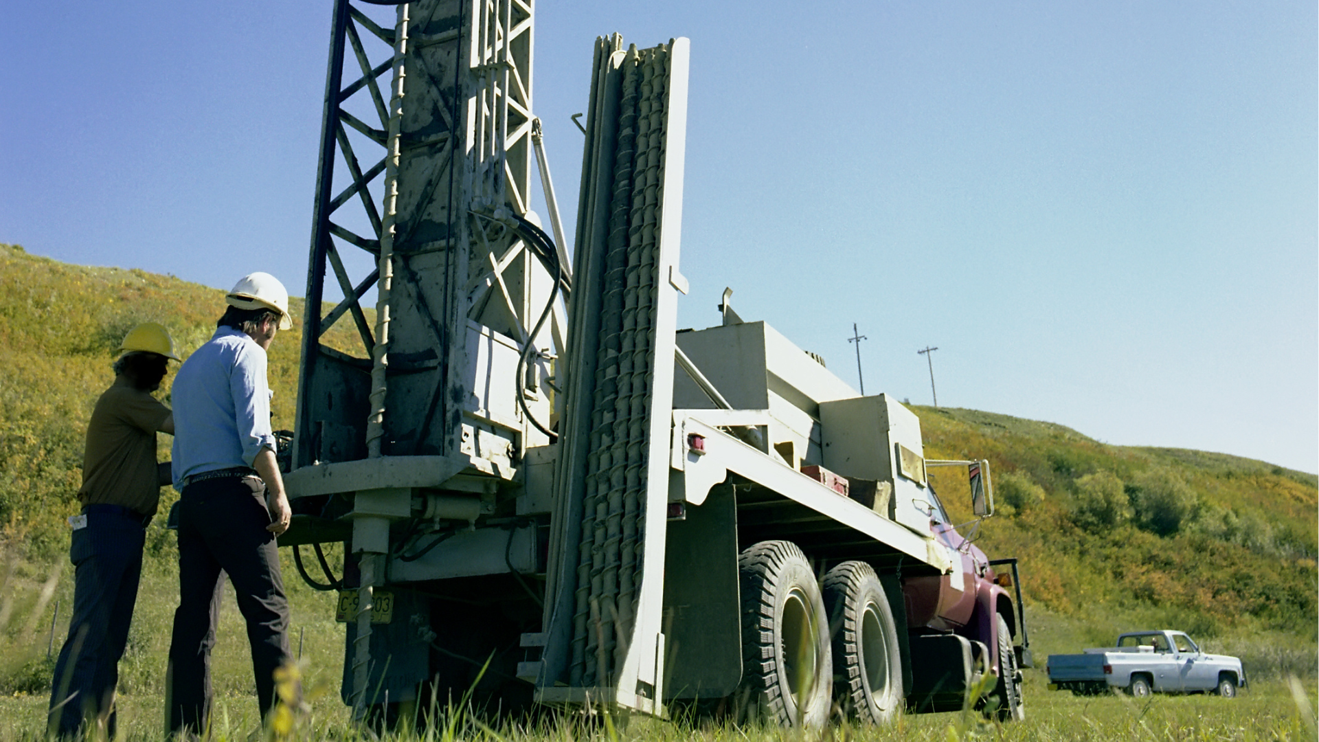
Borehole Logging Software That Connects the Entire Subsurface Data Lifecycle
Capture borehole data in the field, connect stratigraphy, SPT, recovery and sample records, bring laboratory results into the same workflow, and turn the complete dataset into standardized borehole logs and reports. Less administrative work. More connected subsurface data.
Built for geotechnical engineering firms, environmental consultants and site investigation teams across Canada, the United States, Australia and beyond.Borehole Data Shouldn't Have to Be Rebuilt After the Fieldwork
In many workflows, borehole information moves through field logging, stratigraphy, samples, laboratory results and reporting — and where those steps are managed separately, teams may need to re-enter depths, chase sample IDs and rebuild the same stratigraphy before the report goes out.
aQRate goes beyond digitizing the field notebook. It connects the entire subsurface data lifecycle — keeping field data, photographs, samples and laboratory information connected to one borehole record.
From the Field Notebook to the Complete Subsurface Record
aQRate connects the stages instead of treating each output as a separate document. The borehole record your engineers sign is backed by the same structured data the driller's helper captured on the platform pad.
Borehole Setup
ID, coordinates, rig, dateField Logging
structured borehole formStratigraphy
layer-by-layer soilsSPT + Recovery
N-values, % recoverySample Identification
sample IDs by depthLaboratory Analysis
results tied to samplesData Consolidation
one connected recordBorehole Log
standardized outputCharts + Maps
spatial + visual insightFinal Report
Assembled from the connected record — not re-typed.
See How aQRate Connects Field Data to Actionable Information
The Borehole Logs workflow is part of a broader aQRate approach to field data management: capture information in the field, keep records structured and connected, synchronize data, and turn field information into useful outputs for teams in the office and in the field. This video is a general overview of the aQRate process — not a Borehole Logs-specific demonstration.
Start With the Borehole Logs Template
A ready-to-use starting point for capturing structured borehole data, connecting samples and laboratory information, and producing standardized borehole outputs — with 22 sample records to explore.
Borehole Field Form
Structured capture in the field.Stratigraphy
Each layer recorded individually.USCS Classification
Structured soil classifications.SPT + Recovery
N-values and % recovery by depth.Sample IDs
Samples tied to borehole and depth.Laboratory Data
Results linked to their samples.Borehole Logs
Standardized log outputs.GPS Mapping
Boreholes plotted spatially.Charts
Visualize selected borehole data.Standard Report
Borehole Log & Drilling Report.Lithology Log
Borehole ID
Sample ID
From (m)*
To (m)*
Primary Soil Type*
Special & Regional Formations-Type
Gravels & Gravel Mixtures-Type
Sands & Sand Mixtures-Type
Fine-Grained Soils-Type
Color*
Moisture*
Consistency/Density*
Lithology Log
BH-02
BH02-185
15
18.5
Gravels & Gravel Mixtures
—
GP GC - Poorly Graded Gravel with Clay
—
—
Mottled
Moist
Hard
Report ready: Borehole Log & Drilling Report
Reduce Administrative Work in Borehole Data Management by Up to 50%
Capture structured information once, keep related records connected, and reduce the manual work involved in transferring, consolidating, cleaning and assembling borehole data.
An aQRate commercial claim, not an industry benchmark. Actual results depend on your organization's current workflow and how the template is implemented.Capture the Subsurface Layer by Layer
The Borehole Logs template uses a stratigraphy child form, so each subsurface layer is its own structured entry — depth interval, soil type, description, associated sample, SPT information, recovery and photographs where applicable — instead of one long free-text note. Structured selections, including Unified Soil Classification System (USCS) classifications, keep terminology consistent between technicians; the user records the classification, and a trained professional remains responsible for interpreting and classifying the soil.
Borehole BH-01
Lithology Log — child form entries0.0 – 1.2 m
FILL — brown, moist, loose
1.2 – 3.6 m
SM — Silty SAND, medium dense
3.6 – 6.0 m
CL — Lean CLAY, firm, wet
6.0 – 8.4 m
GW — Well graded GRAVEL, dense
Keep Samples, Field Data and Laboratory Results Connected
The sample should remain connected to the borehole and depth from field collection through laboratory analysis and reporting — grain-size analysis, water content, or other applicable tests:
When results come back from the lab, they land beside the sample ID, the depth interval and the stratigraphic layer they belong to — one connected dataset from field collection to the final record. Which tests apply depends on the investigation; aQRate manages the associated information and does not perform the laboratory analysis.
Examples of laboratory data you can connect
One Dataset. Multiple Outputs.
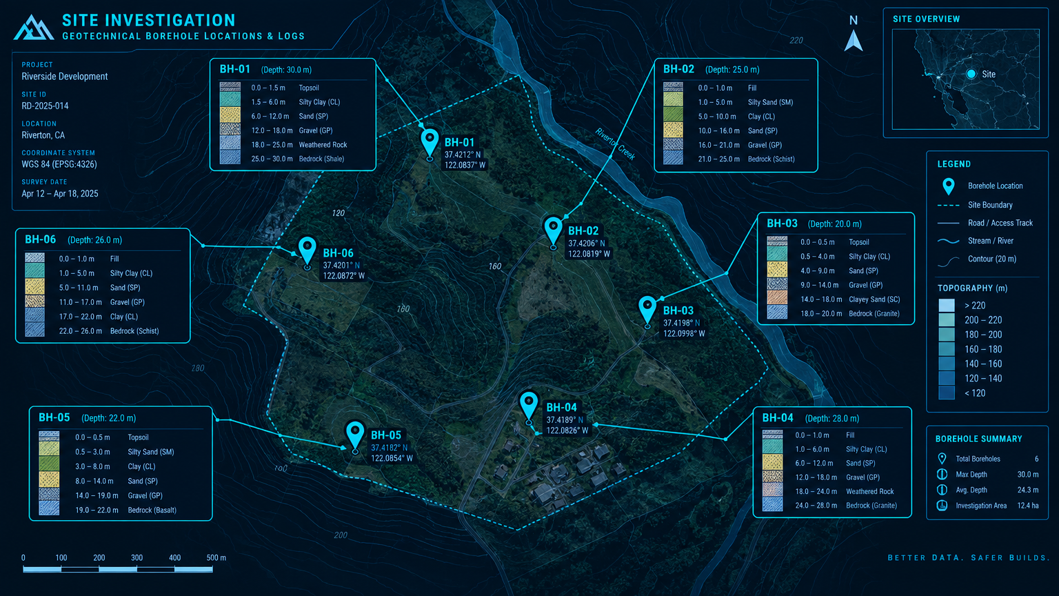
The same structured borehole data supports the standardized borehole log, the GPS map, the charts and the configured report — outputs are assembled from connected records instead of rebuilt by hand.
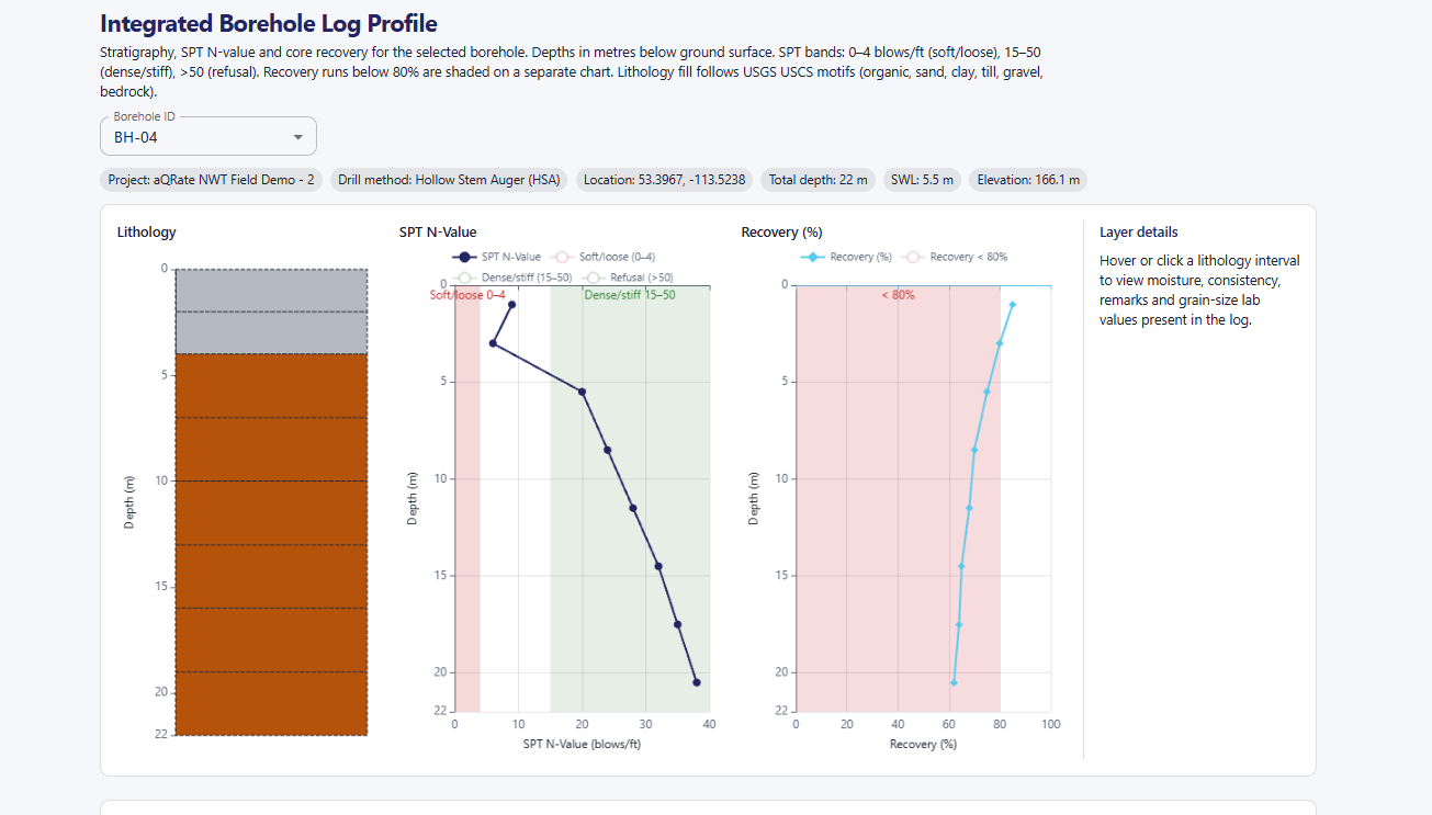
SPT N-values by depth
- SPT N
Percentage recovery by depth
- Recovery %
Know Where Your Data Came From
The value of a borehole record isn't just the final PDF. It is the connected evidence behind it — traceable across every stage of the investigation.
When a reviewer asks "which sample produced this grain-size curve, at what depth, in which borehole?" — the answer is a lookup, not an archaeology project through old field notebooks, spreadsheets and email attachments.
Who Uses aQRate for Borehole Logging?
The teams that feel the fragmentation of separate field records, spreadsheets and lab PDFs the most — across Canada, the United States, Australia and international projects.
Frequently Asked Questions
Borehole logging software lets field teams capture subsurface exploration data — stratigraphy, SPT, recovery and samples — in structured digital forms, then turn that data into standardized borehole logs and reports without re-typing it at every stage.
Yes. The Borehole Logs template uses a stratigraphy child form so each layer is recorded individually, with structured selections for soil type and Unified Soil Classification System (USCS) classifications instead of relying entirely on free text.
Yes — SPT N-values, percentage recovery and sample IDs are captured as structured field data associated with the relevant borehole and depth, using terminology consistent with ASTM D1586/D1586M. The software stores the data; engineering interpretation stays with your qualified professionals.
Yes. Samples identified for analysis — such as grain-size or water content — stay linked to their borehole, depth interval and stratigraphic layer, and laboratory results are attached to the same record. aQRate manages the information; it does not perform the laboratory analysis.
Yes. Each borehole's GPS location is captured in the field, so boreholes plot on a map for reviewing the spatial distribution of the investigation and connecting mapped locations to the underlying records. The map does not automatically create a subsurface model.
Yes. The Borehole Logs Starter Template includes a standard borehole log visualization and the Borehole Log & Drilling Report, generated from the structured dataset. Professional review is still required before submission.
The USCS is a widely used soil classification system that groups soils by grain size and plasticity into classes like SM (silty sand) or GW (well graded gravel). It is the classification system itself — distinct from USGS, the U.S. Geological Survey. aQRate provides structured selections; the user records the applicable classification.
Yes. aQRate's native iOS and Android apps are offline-first — field crews capture structured borehole data without connectivity, and it synchronizes automatically when a connection returns.
Connect Your Borehole Data From Field to Report
See how aQRate can help your team capture structured borehole data, keep samples and laboratory information connected, and turn field records into standardized logs, visualizations and reports.
Explore aQRate
See the platform, understand how it works, explore pricing, or discover more aQRate insights.